You Won’t Believe What This Desert Hides—Death Valley’s Wild Terrain Exposed
Death Valley isn’t just sand and sun—it’s a land of extremes that defies imagination. I never expected to find salt polygons, volcanic craters, and glowing dunes in one place. This isn’t your average desert; it’s a geological masterpiece shaped by fire, ice, and time. If you're chasing unique landscapes that feel otherworldly, this is it. Let me take you through the most jaw-dropping terrain on Earth—where nature goes way beyond expectations.
Entering the Extreme: What Makes Death Valley Unique
Death Valley National Park stands as one of the most extraordinary landscapes in North America, not merely because of its reputation for heat, but because of the powerful geological forces that have shaped it over millions of years. Located in eastern California, it holds the record for the highest air temperature ever recorded on Earth—134°F (56.7°C) in 1913 at Furnace Creek. It is also home to the lowest elevation in the Western Hemisphere, sitting 282 feet below sea level at Badwater Basin. These extremes are not random; they are the result of a rare combination of tectonic activity, climate, and geography that make Death Valley a natural laboratory of geological transformation.
The valley lies within the Basin and Range Province, a vast region where the Earth's crust has been stretched and thinned. This extension has caused blocks of land to drop down between parallel faults, forming what geologists call a graben. Death Valley is one such graben—a sunken block bounded by uplifted mountain ranges like the Panamint Range to the west and the Amargosa Range to the east. This tectonic pulling apart has allowed the valley floor to sink deeply, creating space for sediment and salt to accumulate over millennia. The depth of this subsidence, combined with its position in the rain shadow of the Sierra Nevada, results in an environment of extreme aridity.
The Sierra Nevada mountains block moisture-laden storms coming from the Pacific Ocean. By the time air masses cross these towering peaks, they have lost most of their moisture, descending into the valley as dry, warm winds. This rain shadow effect means Death Valley receives less than two inches of rain per year on average, classifying it as a hyper-arid desert. Yet, despite the lack of regular rainfall, water plays a crucial role in shaping the landscape. Infrequent but intense storms can trigger flash floods that carve canyons, redistribute sediments, and temporarily fill ancient lake beds. These episodic events, combined with relentless evaporation, contribute to the formation of salt flats, mud cracks, and other striking surface features.
What sets Death Valley apart from other deserts is not just its harsh climate, but the dynamic interplay of geological processes still actively unfolding. Unlike static deserts dominated by sand dunes, Death Valley is a place of constant change—where the ground shifts, cracks, and reforms; where volcanoes have erupted within human memory; and where ancient lakes have come and gone. This combination of extreme elevation changes, tectonic motion, volcanic activity, and climatic forces creates a landscape that is as scientifically significant as it is visually stunning. For the curious traveler, understanding these foundational elements enhances every visit, turning a simple sightseeing trip into a journey through deep time and planetary power.
Badwater Basin: Walking on a Cracked Sea of Salt
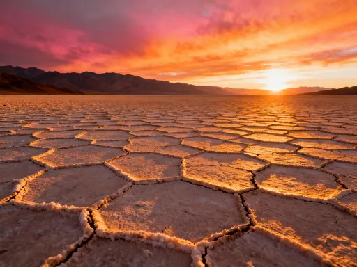
Standing at Badwater Basin, it’s easy to feel as though you’ve stepped onto another planet. The ground beneath your feet is a vast, blinding white expanse that stretches toward the horizon, cracked into intricate geometric patterns that resemble a giant jigsaw puzzle. At 282 feet below sea level, this is the lowest point in North America, and one of the most surreal destinations within Death Valley National Park. Once part of a massive prehistoric lake known as Lake Manly, which covered the valley during the last ice age, Badwater Basin is now a dry lake bed—or playa—dominated by a thick crust of crystallized salt. The name “Badwater” comes from early explorers who found the water here too salty to drink, a reminder of the valley’s unforgiving nature.
The salt covering the basin is primarily composed of sodium chloride, deposited over thousands of years as water from surrounding mountains carried minerals into the valley. During rare rain events, water flows into the basin, dissolving salt from the rocks and soil. As the water evaporates under the relentless desert sun, it leaves behind concentrated salt deposits. Over time, this cycle has built up a salt crust several feet thick in places. What makes the surface so visually captivating are the hexagonal salt polygons—cracks that form as the salt crust expands and contracts with temperature changes. When the surface heats up during the day, it expands; at night, it cools and contracts. This repeated stress causes the crust to fracture in a pattern that nature favors: six-sided shapes that efficiently distribute tension across the surface.
Walking across Badwater Basin is an experience unlike any other. The crunch of salt underfoot echoes in the still air, and the flat, reflective surface creates shimmering mirages that distort the horizon. On hot days, the air above the salt heats unevenly, bending light and producing illusions of water where none exists. These optical effects add to the dreamlike quality of the landscape. Interpretive signs along the boardwalk explain the geology, but nothing compares to seeing it firsthand. The boardwalk extends about a quarter-mile onto the salt flat, allowing visitors of all mobility levels to experience the terrain safely. Beyond the boardwalk, footprints can be seen crisscrossing the expanse, evidence of adventurers who’ve ventured further into this otherworldly terrain.
Despite its barren appearance, Badwater Basin is not lifeless. In the right conditions, life finds a way. After significant rainfall, a rare species of brine shrimp and a type of algae can appear in temporary pools, turning the water pink. These fleeting ecosystems attract migratory birds, creating brief but vibrant bursts of activity in an otherwise silent landscape. The resilience of these organisms underscores a central theme of Death Valley: even in the harshest environments, life persists. For visitors, Badwater Basin is more than a photo opportunity—it’s a meditation on time, change, and the quiet power of natural processes that shape our planet.
Artist’s Palette: Where Volcanoes Paint the Hills
One of the most iconic drives in Death Valley leads to Artist’s Palette, a hillside transformed into a living painting by the hand of geology. Located along the Artists Drive, a nine-mile one-way loop road that descends into a narrow canyon, this site reveals slopes streaked with vibrant hues of gold, lavender, green, pink, and rust. The colors are so intense and varied that they seem almost artificial, as if a giant artist had swept brushes of pigment across the rock. Yet every shade is entirely natural, the result of mineral oxidation and hydrothermal alteration that occurred thousands of years ago. This is not a static display—it’s a dynamic record of volcanic activity, weathering, and chemical change written in stone.
The palette of colors originates from ancient volcanic eruptions that spewed ash and lava across the region. Over time, these volcanic deposits were altered by hot, mineral-rich groundwater in a process known as hydrothermal alteration. As the water circulated through the rock, it changed the chemical composition of the minerals, particularly those containing iron, manganese, and other trace metals. Iron oxidizes to produce reds, oranges, and yellows—similar to how rust forms on metal. Manganese compounds create purples and pinks, while trace amounts of other elements contribute to greens and blues. The varying intensity of these reactions, combined with differences in rock composition and exposure to air and water, results in the complex banding and streaking visible today.
The best time to visit Artist’s Palette is during the golden hours—shortly after sunrise or before sunset—when the low-angle sunlight enhances the colors and casts long shadows that add depth to the terrain. At midday, the harsh overhead sun can wash out the hues, making them appear flatter and less vivid. The drive itself is an adventure, with steep switchbacks and narrow roads that require careful navigation, especially for larger vehicles. Pullouts along the way offer safe spots to stop and take in the views. A short, paved path leads to the main viewpoint, where interpretive signs explain the geology and provide context for what you’re seeing.
Photographers and artists alike are drawn to this location, not only for its beauty but for its symbolic resonance. Artist’s Palette serves as a powerful reminder that nature is not just functional—it is also expressive. The earth, over immense stretches of time, creates works of art without intention, driven solely by chemical and physical laws. For visitors, standing before this kaleidoscopic hillside can evoke a sense of wonder and humility. It’s a place where science and aesthetics converge, inviting reflection on the slow, patient forces that shape our world. Artist’s Palette is more than a scenic stop; it’s a testament to the creative power of the Earth itself.
Ubehebe Crater: A Volcanic Punch in the Desert
Rising abruptly from the flat expanse of Death Valley’s northern region, Ubehebe Crater is a dramatic reminder that the Earth is still alive beneath our feet. Measuring half a mile wide and 500 feet deep, this massive bowl-shaped depression looks like the aftermath of a meteor strike, but its origin is terrestrial and relatively recent—geologically speaking. Formed approximately 2,100 years ago, Ubehebe was created by a phreatomagmatic explosion, a violent event that occurs when rising magma encounters groundwater. The resulting steam explosion blasted through the surface, ejecting rock and ash high into the air and carving out the crater in a matter of seconds. This makes Ubehebe one of the youngest volcanic features in the park, offering a rare glimpse into active geological processes.
The crater is part of a larger volcanic field that includes at least a dozen smaller craters and cinder cones scattered across the surrounding area. These features indicate that the volcanic activity was not a single event but a series of eruptions over several hundred years. The magma involved was relatively low in silica, making it less explosive than the types that produce towering volcanoes like Mount St. Helens. Instead, the explosiveness came from the sudden conversion of water to steam, which expanded with tremendous force. Scientists have studied the layers of ash and debris around Ubehebe to reconstruct the sequence of eruptions, finding evidence of multiple explosions that varied in intensity.
Visitors can hike around the rim of Ubehebe Crater on a well-maintained trail that forms a loop of about 1.5 miles. The path offers panoramic views into the crater’s interior, where layers of black and red volcanic rock are exposed along the walls. At the bottom, a flat, sandy floor is occasionally dotted with wildflowers after winter rains. The trail is moderately strenuous due to loose gravel and a slight elevation gain, but it is accessible to most hikers with proper footwear and hydration. Along the way, side trails lead to smaller craters like Little Hebe, which provide additional insights into the volcanic history of the area.
Safety is important when visiting Ubehebe. The area has no shade, and summer temperatures can be dangerous. It’s essential to carry plenty of water, wear sun protection, and avoid hiking during the hottest part of the day. While the crater appears stable, the rim edges can be unstable in places, so visitors should stay on designated paths. Despite its remote location, Ubehebe Crater is a powerful destination that connects travelers with the raw energy of the Earth. It’s a place where the planet’s inner heat meets the surface in a flash of violence, leaving behind a scar that continues to inspire awe centuries later.
Mesquite Flat Sand Dunes: Shifting Gold Under Moonlight
Among the most photographed and visited features in Death Valley, the Mesquite Flat Sand Dunes rise like golden waves against the stark desert backdrop. Located near Stovepipe Wells, these dunes are easily accessible and offer a striking contrast to the valley’s salt flats and rocky canyons. Reaching heights of up to 100 feet, the dunes are composed of fine, windblown sand that has accumulated over thousands of years. Unlike dunes in other deserts that are stabilized by vegetation, these are active—constantly reshaped by the prevailing winds that sweep through the valley. This dynamism gives the dunes their smooth, flowing contours and ever-changing patterns, making each visit a unique visual experience.
The sand itself originates from the erosion of nearby mountains, particularly the Panamint Range. Over time, streams and flash floods carried sediment into the valley, where wind took over the process of transportation. Finer particles were winnowed away, leaving behind quartz grains that shimmer in the sunlight. The name “Mesquite Flat” comes from the mesquite trees that grow at the base of the dunes, their deep roots tapping into underground moisture. These trees serve as natural anchors, helping to define the edge of the dune field and providing rare shade in an otherwise exposed environment.
For photographers and nature lovers, the best times to visit are early morning and late afternoon, when the low sun casts long shadows that accentuate the dunes’ ridges and troughs. The interplay of light and texture creates dramatic compositions that capture the fluidity of the landscape. At sunrise, the dunes glow in warm hues of orange and pink; at sunset, they deepen into rich golds and ambers. On full moon nights, some visitors come to witness the dunes under moonlight, when the sand takes on a silvery sheen and the silence is profound. On rare occasions, people report hearing the dunes “sing”—a low, humming sound produced when dry sand grains avalanche down the slopes, a phenomenon still not fully understood by scientists.
Hiking on the dunes is a favorite activity, though it can be physically demanding. The loose sand makes every step a challenge, quickly revealing the strength required to walk on shifting ground. There are no marked trails, allowing for free exploration, but visitors should be mindful of leaving footprints in pristine areas. Those seeking solitude can walk farther from the parking area, where the dunes become quieter and more isolated. While the dunes may appear barren, they support a surprising amount of life, including beetles, lizards, and nocturnal rodents adapted to the extreme conditions. For many, standing atop a dune and looking out across the silent, rippling landscape evokes a deep sense of peace and connection to the natural world.
Dante’s View: The Overlook That Changes Everything
Perched at an elevation of 5,475 feet on the crest of the Black Mountains, Dante’s View offers one of the most breathtaking panoramas in the entire national park system. From this vantage point, visitors can see the full breadth of Death Valley laid out below, from the glistening white salt flats of Badwater Basin, 300 feet below sea level, to the rugged peaks of the Panamint Range rising over 11,000 feet above. The sheer scale of the landscape is staggering, revealing the tectonic drama that created this unique valley. On clear days, the curvature of the Earth seems visible, and the contrast between light and shadow across the basin creates a painterly effect that shifts with the time of day.
Dante’s View is more than just a scenic overlook—it’s a geological classroom. The elevation difference between the viewpoint and Badwater Basin is greater than the height of many mountains, illustrating the immense forces that have pulled the valley apart. To the west, the Panamint Range represents the uplifted edge of a fault block, while the valley floor is the down-dropped graben. This dramatic relief is a textbook example of extensional tectonics, a process still active today. Interpretive signs at the site explain these concepts, helping visitors understand the forces that shaped the terrain they’re seeing.
The best times to visit are sunrise and sunset, when the changing light transforms the valley floor. At dawn, the first rays of sun illuminate the Panamint peaks in alpenglow while the valley remains in shadow, creating a dramatic contrast. As the sun rises, light slowly creeps down the mountainside, eventually reaching the salt flats and setting them ablaze in reflected brilliance. At sunset, the process reverses, with the valley glowing warmly while the higher peaks turn cool and blue. These transitions offer some of the most photogenic moments in the park.
Because of its high elevation, Dante’s View is significantly cooler than the valley floor, making it a welcome escape during summer months. However, weather can change quickly, and the road to the summit is narrow and winding, requiring caution, especially for large vehicles. Despite these challenges, the journey is well worth it. Standing at Dante’s View, one gains not just a visual spectacle, but a deeper understanding of the forces that shape our planet. It is a place of perspective—where the vastness of nature puts human concerns into humble context and inspires a quiet reverence for the Earth’s enduring power.
Planning Your Visit: When to Go, What to Bring, and How to Stay Safe
Visiting Death Valley is a rewarding experience, but it demands careful planning and respect for the environment. The extreme conditions that make the park so unique also make it potentially dangerous, especially during the summer months when daytime temperatures regularly exceed 120°F (49°C). The best time to visit is between late October and early April, when daytime highs are more moderate, ranging from the 70s to 80s°F (21–27°C), and nighttime temperatures, while cold, are manageable with proper clothing. Spring also brings the possibility of wildflower blooms, particularly in years with above-average rainfall, adding another layer of beauty to the landscape.
Preparation is key. Every visitor should carry at least one gallon of water per person per day, and more if planning hikes. Dehydration can occur rapidly, even in cooler months, due to the dry air and high levels of physical activity. Sun protection is essential: wide-brimmed hats, UV-blocking sunglasses, and broad-spectrum sunscreen should be standard. Lightweight, long-sleeved clothing helps protect against sunburn while allowing breathability. Sturdy footwear is important, especially for hiking on rocky or sandy terrain. A reliable map or GPS device is crucial, as cell phone service is extremely limited throughout the park.
The park has several paved roads that provide access to major attractions, but some sites require travel on unpaved roads that may be rough or impassable after rain. Before setting out, check road conditions with park rangers. Fuel should be topped off before entering, as gas stations are sparse and far apart. Campgrounds are available at Furnace Creek, Stovepipe Wells, and other locations, but reservations are recommended during peak season. Backcountry camping is allowed in designated areas with a free permit, offering a chance to experience the desert’s profound silence and star-filled skies.
Safety also means knowing your limits. Hike during the cooler parts of the day, avoid strenuous activity in extreme heat, and never leave marked trails, which helps protect fragile desert ecosystems. All trash must be packed out, as there are no public waste disposal facilities in remote areas. In case of emergency, know that help may be hours away—carry a fully charged emergency beacon or satellite communicator if venturing off the beaten path. Above all, respect the desert. Its beauty is matched only by its severity, and those who prepare wisely will find Death Valley not just survivable, but deeply transformative.
Conclusion
Death Valley’s terrain tells a story of Earth’s raw power—of sinking lands, erupting craters, and evaporating seas. It’s not just a place to visit, but a place to understand. Each landscape offers a lesson in geology, resilience, and scale. From the salt polygons of Badwater Basin to the volcanic fury of Ubehebe Crater, from the painted hills of Artist’s Palette to the silent dunes glowing under moonlight, this desert reveals the forces that have shaped our planet over millions of years. Dante’s View reminds us of the vastness of nature, while the careful planning required to visit teaches humility and respect.
For travelers seeking authenticity and wonder, Death Valley delivers beyond imagination. It does not cater to comfort or convenience. Instead, it asks for presence, curiosity, and courage. The true adventure isn’t just seeing it—but feeling how small you are in a world shaped by time and force. In a world of curated experiences and digital distractions, Death Valley remains real, untamed, and profoundly moving. It is a destination that changes how you see the Earth—and yourself.